May 29, 2026
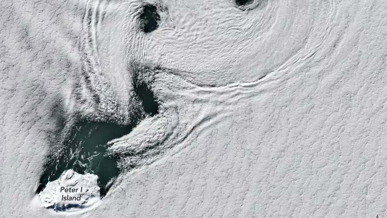
NASA’s Earth Observatory has released striking satellite imagery capturing a rare and mesmerizing meteorological phenomenon: a vast sea of spinning clouds swirling over one of Antarctica’s most remote volcanic islands. The images, taken by the Moderate Resolution Imaging Spectroradiometer (MODIS) aboard the Terra and Aqua satellites on May 27, reveal an organized field of atmospheric vortices extending for hundreds of kilometers downwind of Zavodovski Island, a small, uninhabited stratovolcano in the South Sandwich archipelago.
This dramatic cloud formation, known in fluid dynamics as a von Kármán vortex street, occurs when a prominent obstacle—here the island’s 551-meter-high Mount Curry—disrupts a layer of low-lying, stable air. As the wind slams into the volcanic peak, it splits around the island, creating alternating eddies that spin clockwise and counterclockwise, producing a hypnotic, ladder-like pattern of swirling white spirals against the dark grey of the Southern Ocean. NASA scientists confirmed that the vortex street extended for more than 1,100 kilometers from the island, with individual eddies measuring up to 30 kilometers in diameter—an atmospheric signature both beautiful and scientifically invaluable.
Dr. Elena Pavlova, an atmospheric physicist at NASA’s Goddard Space Flight Center, explained the rarity of such a clear capture over polar regions: “We routinely observe von Kármán vortex streets in tropical and mid-latitude oceans, for example behind the Canary Islands or Madeira. But over Antarctica—with its extreme cold, sea ice, and frequent cloud cover—a perfectly illuminated, nearly cloud-free image like this is exceptional. The fact that we saw this on May 29, deep into austral autumn, is remarkable.
The air temperature was around –15°C, and the wind speed at cloud height was estimated at 65 kilometers per hour, blowing from the northwest. The island’s sharp volcanic cone acted like a rock in a fast-flowing atmospheric river, and the result was a flawless vortex street.” The phenomenon is not merely aesthetic; it provides a natural laboratory for understanding how obstacles perturb fluid flows—a principle that applies to air moving over mountains, water flowing around bridge piers, or even plasma moving through magnetic fields.
Dr. Marcus Thorne, a polar meteorologist at the British Antarctic Survey, emphasized the scientific value of such imagery: “Each vortex pair tells us about the vertical wind shear, the stability of the atmospheric boundary layer, and even the roughness of the island’s surface. From these satellite data, we can calculate how energy is transferred from large-scale winds into small-scale turbulence—a key process for modeling polar weather and climate. Moreover, Zavodovski is one of the most active volcanic environments in the Antarctic region, famous for its chinstrap penguin colonies and constant emission of sulfuric gases. This vortex street could actually be carrying volcanic aerosols and trace gases far downwind, affecting cloud chemistry and radiation balance over the Southern Ocean.” Indeed, Zavodovski, nicknamed “Puffin Island” for its seabird populations, last erupted in 2016, and though no fresh eruption was reported this week, background degassing means the spinning clouds may be lightly seeded with volcanic particles.
The timing of the capture is also scientifically serendipitous. On May 29, 2026, the European Space Agency’s Sentinel-6 Michael Freilich altimetry satellite was passing over the same region, allowing for a rare multi-platform validation of sea surface winds and atmospheric pressure gradients. NASA’s Landsat 9 also acquired high-resolution thermal imagery of the vortex cores, revealing that the cloud droplets in the spinning arms were composed of supercooled liquid water—a critical detail for cloud microphysics models. “Supercooled water clouds are notoriously difficult to simulate in global climate models,” noted Dr. Aisha Khan, a cloud physicist at the University of Colorado Boulder. “Seeing them organize into such perfect vortices gives us a controlled case study to test our parameterizations. If a model cannot reproduce the size, spacing, and spin direction of these clouds, then it cannot be trusted for polar climate projections.”
For the general public, the image is a stark reminder of Antarctica’s hidden dynamism. The continent is often portrayed as a static, white desert, yet here—above a volcanic island visited only by a handful of researchers and hardy cruise ships each year—the atmosphere is performing intricate choreography visible only from space. Social media channels run by NASA’s Earth Observatory saw a surge in shares and comments, with many users comparing the vortex street to a “galaxy of tiny hurricanes,” a “cloud fingerprint,” or a “spiral dance of wind and rock.” NASA responded by releasing a time-lapse animation compiled from four consecutive satellite passes between 02:30 and 14:30 GMT on May 27, showing the vortices not as static spirals but as propagating structures that gradually dissipate as they drift into the ice-covered Weddell Sea.
The phenomenon has no immediate impact on human activity, as Zavodovski Island lies over 2,000 kilometers from the nearest research stations at Signy or King Edward Point. However, it holds indirect value for aviation and shipping safety in the Southern Ocean. “These vortices generate localized wind shear and turbulence that can be hazardous for low-flying helicopters or small vessels,” explained Commander Leila Rostami of the Chilean Navy’s Antarctic Hydrographic Unit. “Knowing how and when they form helps us improve our polar weather warnings. No one wants to navigate through a hidden rotor zone created by an island they cannot even see on the horizon.”
Looking ahead, NASA plans to integrate this event into an educational module for students learning about fluid dynamics and Earth observation. As Dr. Pavlova concluded: “Every time we look at our planet from orbit, we see something that challenges our assumptions. A tiny volcanic island, a steady wind, and a camera in space—that is all it takes to reveal a universe of swirling order inside what looks like chaos. This is why we observe. This is why Antarctica, even in autumn, never stops surprising us.” The full-resolution images and animation are publicly available on the NASA Earth Observatory website, where they will remain as a testament to the invisible rhythms sculpting our atmosphere—one perfect spiral at a time.