La Niña is a climatic phenomenon characterized by the abnormal cooling of sea surface temperatures in the central and eastern equatorial Pacific Ocean. It is a counterpart to El Niño, which involves the warming of these waters. Together, they form the El Niño-Southern Oscillation (ENSO) cycle, a significant driver of global climate variability. The term “La Niña,” Spanish for “the girl,” was chosen to emphasize its contrast with El Niño (“the boy”). La Niña events typically last between 9 to 12 months but can persist for up to two years. La Niña arises from complex interactions between the ocean and the atmosphere. These interactions are governed by trade winds, which blow from east to west across the equatorial Pacific. During La Niña, these winds strengthen, pushing warm surface water westward toward Asia and allowing colder water from the ocean depths to upwell in the eastern Pacific.
The Walker Circulation, an east-west atmospheric circulation pattern over the tropical Pacific, intensifies during La Niña. As the trade winds strengthen, they enhance the upwelling of cold water in the eastern Pacific, reinforcing the cooling trend. Meanwhile, convection and rainfall are displaced westward, leading to increased precipitation in regions like Southeast Asia and northern Australia. Although the precise triggers of La Niña are not fully understood, it is believed to result from natural variability in the climate system. External factors, such as volcanic eruptions or changes in solar radiation, may also play a role. Additionally, La Niña events sometimes follow El Niño episodes as part of the ENSO cycle.
Characteristics of La Niña
The defining feature of La Niña is a significant drop in sea surface temperatures (SSTs) in the central and eastern Pacific, often by 1°C to 3°C below average. Along with this, the enhanced trade winds amplify the cooling effect by facilitating upwelling. Convection zones move westward, leading to wetter conditions in some regions and drier conditions in others. Certain areas experience a rise in tropical cyclone activity, particularly in the western Pacific and Indian Ocean. The atmospheric circulation becomes more robust, reinforcing the east-west weather patterns associated with La Niña. While the equatorial Pacific experiences cooling, some regions, like parts of North America, may face colder winters or milder conditions depending on local interactions.
Effects of La Niña on different parts of the world
Asia-Pacific Region
La Niña exerts a pronounced influence on the Asia-Pacific, with varying effects across countries. In India, La Niña typically correlates with a stronger monsoon season, increasing agricultural productivity but also raising the risk of flooding. In contrast, parts of Indonesia and the Philippines, prone to excessive rainfall, may face landslides and infrastructure damage. Australia’s eastern regions often benefit from enhanced rainfall, supporting water reservoirs and agricultural activities, though excessive rain can lead to flash floods and crop losses.
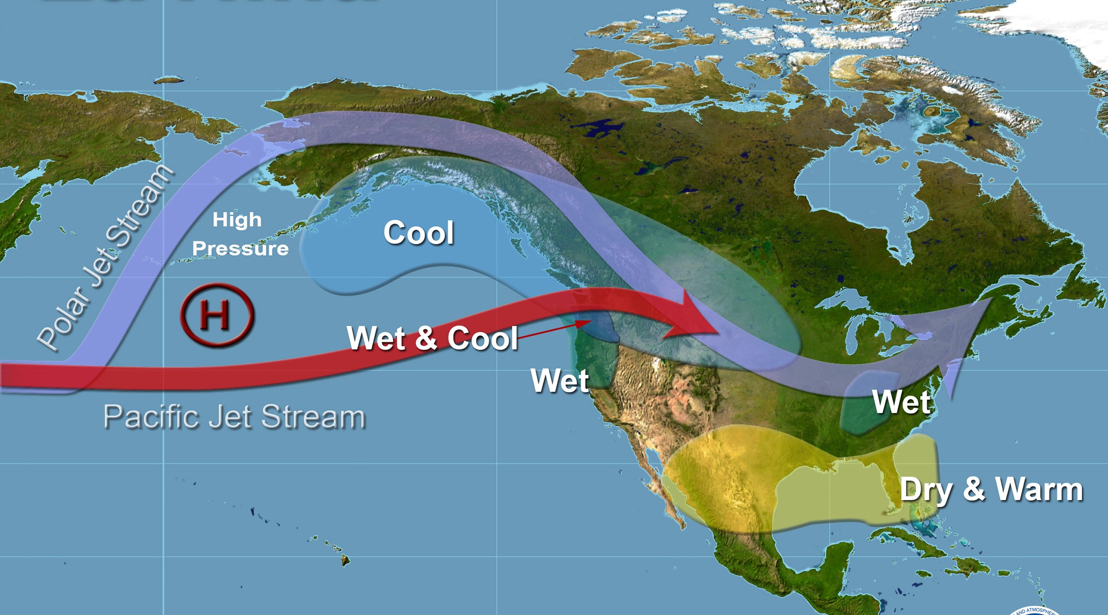
North America
The effects of La Niña in North America depend on the season. During winter, the Pacific Northwest experiences wetter and colder conditions, increasing the risk of snowfall and floods. In contrast, the southeastern United States often faces above-average rainfall, while the southwestern states endure drier conditions, exacerbating droughts and water scarcity. The Gulf Coast is at higher risk of hurricanes due to warmer Atlantic waters and favorable wind patterns during La Niña years.
South America
La Niña intensifies the contrast in weather patterns across South America. Northern countries, including Colombia and Venezuela, often face increased rainfall, elevating the risk of flooding. Conversely, southern regions like Chile, Argentina, and southern Brazil experience drier conditions, negatively impacting agriculture and hydroelectric power generation.
Africa
La Niña’s impacts in Africa vary between regions. In East Africa, La Niña often brings above-average rainfall, leading to floods, soil erosion, and waterborne diseases. This was evident during the 2016-2017 La Niña event, which caused significant flooding in Kenya and Somalia. In contrast, southern Africa’s agricultural output suffers during La Niña due to decreased rainfall and prolonged droughts, affecting food security and economies reliant on subsistence farming.
Europe
While Europe is less directly affected by La Niña compared to other continents, indirect effects are observed through altered atmospheric jet streams. La Niña winters often bring colder conditions to northern Europe and milder, wetter weather to southern Europe.
Effect of La Niña on marine life
La Niña profoundly influences marine ecosystems, particularly in the Pacific Ocean. The cooling of sea surface temperatures and the associated upwelling of nutrient-rich waters create unique conditions that affect marine biodiversity and fisheries. Upwelling in the eastern Pacific increases nutrient availability, leading to phytoplankton blooms. This forms the foundation of the marine food chain, benefiting fish populations, particularly species like anchovies and sardines. Regions such as the coasts of Peru and Ecuador experience a boost in fishery productivity due to the abundance of small pelagic fish. Cooler water temperatures may drive some marine species to migrate to warmer areas, altering traditional ecosystem dynamics. Marine mammals, such as sea lions and dolphins, may benefit from increased fish availability in upwelling zones. Seabird populations, particularly those reliant on fish, also thrive during La Niña periods as their primary food sources become more abundant. Predator-prey relationships can shift as species adapt to changing habitats. Changes in ocean currents and nutrient cycling during La Niña can affect deep-sea ecosystems by altering the deposition of organic matter. Unlike El Niño, which causes coral bleaching due to warmer waters, La Niña’s cooler waters may provide temporary relief for coral reefs. However, extreme La Niña events can still disrupt delicate marine ecosystems. Fisheries reliant on stable ocean conditions may experience disruptions as fish stocks concentrate in nutrient-rich upwelling zones. Countries dependent on fishing industries, such as Peru, often see economic benefits during La Niña due to increased fish yields.
Effect of La Niña on ecosystem
Wetter conditions in some regions promote plant growth and biodiversity. Drought-prone areas may experience habitat loss and decreased agricultural productivity. La Niña can benefit agriculture in regions with increased rainfall, such as parts of Southeast Asia and Australia. Droughts and floods disrupt crop yields, leading to food insecurity in affected areas. Agricultural products like rice, wheat, and coffee are affected by changes in production levels, influencing global prices. La Niña events often bring increased rainfall, benefiting agriculture but also causing devastating floods. For example, the 2010-2011 La Niña event led to widespread flooding in Queensland, causing billions of dollars in damages. The Pacific Northwest typically experiences wetter conditions during La Niña, while the Southwest faces drier winters. The 2010-2011 La Niña contributed to severe drought in Texas, impacting agriculture and water resources.

Current status on La Niña
Current research and observations about La Niña in late 2024 focus on its development and potential impacts on global weather patterns. The tropical Pacific Ocean is transitioning from ENSO-neutral conditions, with a possibility of a weak La Niña developing between October-December 2024. Subsurface ocean temperatures in the central and eastern Pacific remain slightly below average, which aligns with La Niña tendencies. However, the trade winds and convection patterns are close to normal, making this a weaker-than-usual event. A 57% probability exists for La Niña to persist through January-March 2025, though it is expected to remain weak and short-lived. This could influence global weather, particularly in areas prone to La Niña effects, such as drier winters in the southern U.S. and wetter conditions in parts of Southeast Asia and Australia. Weak La Niña events tend to produce less predictable weather effects compared to stronger events. For example, precipitation and temperature patterns may deviate from typical La Niña outcomes. Researchers emphasize monitoring ocean-atmosphere interactions to refine forecasts and assess regional impact.
Following is the official CPC ENSO (Climate Weather Linkage: El Niño Southern Oscillation) probability forecast, based on a consensus of CPC and IRI forecasters. It is updated during the first half of the month, in association with the official CPC ENSO Diagnostic Discussion. It is based on observational and predictive information from early in the month and from the previous month. It uses human judgment in addition to model output, while the forecast shown in the Model-Based Probabilistic ENSO Forecast relies solely on model output. This is updated on the second Thursday of every month.
La Niña is a natural climatic phenomenon with far-reaching impacts on global weather, ecosystems, and economies. While it presents challenges, advancements in forecasting and proactive measures can mitigate its adverse effects. Understanding La Niña’s dynamics is crucial for building resilience in a changing climate. By fostering global cooperation and investing in adaptive strategies, societies can better navigate the complexities of this powerful climatic force.


