
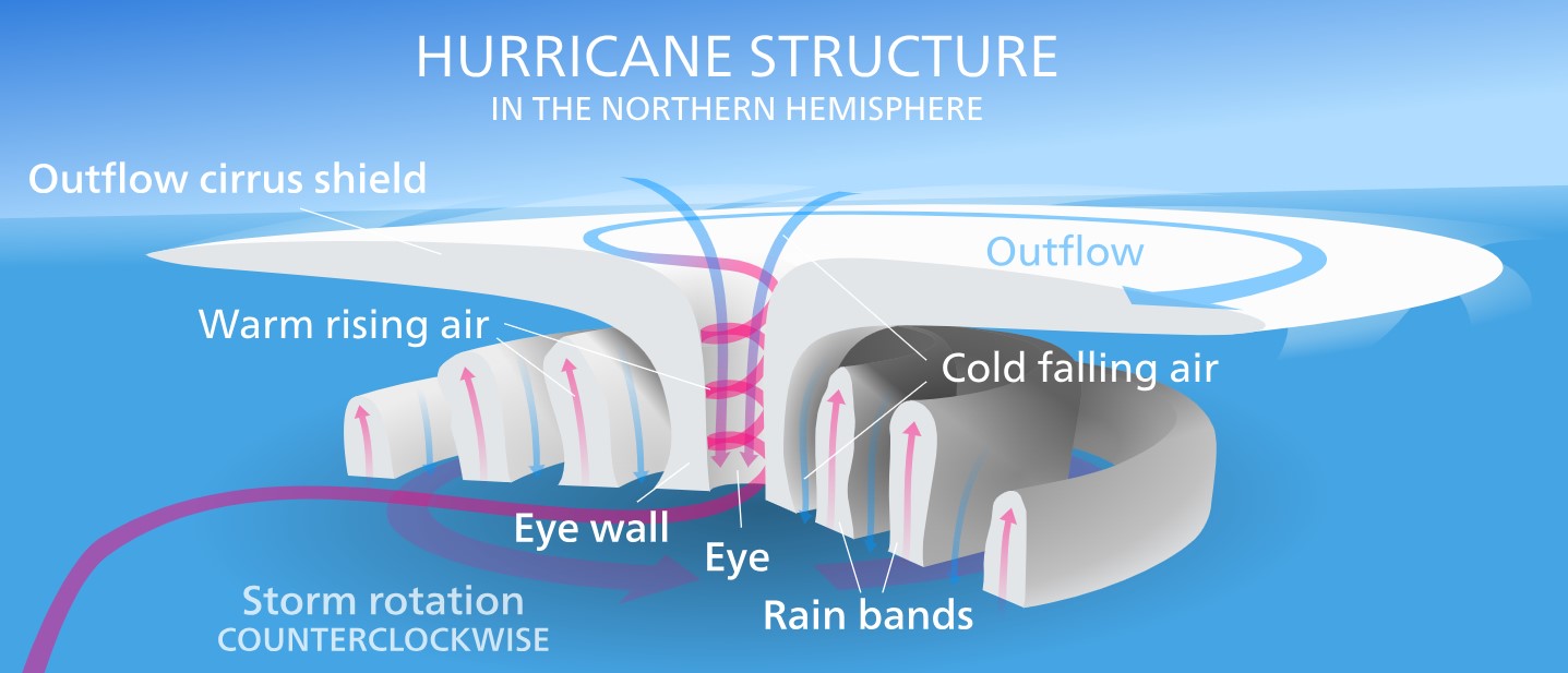
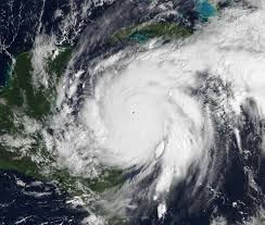
Hurricanes, also known as tropical cyclones or typhoons depending on the region, are among nature’s most formidable forces, capable of reshaping landscapes and altering lives in mere hours. Originating over warm tropical and subtropical waters, these massive storms are powered by heat energy from the ocean. They are characterized by strong, spiraling winds, torrential rains, and a central eye of relative calm. The intricate process of hurricane formation begins with the evaporation of warm ocean water, creating humid, rising air that fuels convection currents. As this warm air rises and cools, water vapor condenses into clouds, releasing latent heat that accelerates the storm’s growth. The Coriolis effect, caused by Earth’s rotation, imparts the spinning motion that defines these systems. Once sustained winds reach 74 mph (119 km/h), a tropical cyclone earns the designation of a hurricane, capable of unleashing catastrophic wind speeds exceeding 150 mph (241 km/h). These phenomena are not random; they form in predictable seasons and regions, yet their precise paths and intensities remain difficult to forecast.
The Duality of Hurricanes: Creation and Destruction
While hurricanes are mesmerizing demonstrations of atmospheric physics, their beauty belies their destructive potential, particularly for coastal communities. These regions, often densely populated and economically significant, bear the brunt of hurricane impacts. The most perilous elements of a hurricane include storm surges, high winds, and relentless rainfall. Storm surges, driven by the storm’s powerful winds and low pressure, push seawater ashore, flooding large swaths of land. Meanwhile, intense winds can level buildings, uproot trees, and disrupt power supplies, leaving communities in darkness for days or weeks. Additionally, heavy rainfall often triggers severe flooding, with rivers and drainage systems overwhelmed by the deluge. Beyond the immediate physical destruction, hurricanes impose long-term social and economic costs. They displace thousands of residents, disrupt businesses, and burden governments with recovery and rebuilding expenses. Furthermore, the environmental toll is immense, with damaged ecosystems, eroded coastlines, and polluted waters compounding the challenges for affected areas.
Resilience and Adaptation in the Face of Hurricanes
Despite their destructive capabilities, hurricanes also inspire resilience and innovation among those who live in their paths. Coastal communities have developed an array of strategies to mitigate the impact of these storms and safeguard lives and property. Advanced weather forecasting technologies provide critical lead time, enabling timely evacuations and preparations. Engineers have designed hurricane-resistant structures, while natural defenses such as mangroves and coral reefs are increasingly recognized for their ability to buffer storm surges. However, as climate change accelerates, the frequency and intensity of hurricanes may increase, posing new challenges. Warmer oceans and rising sea levels amplify storm strength and expand their reach, threatening areas previously considered safe. This reality underscores the importance of comprehensive disaster planning, international cooperation, and sustainable development practices. By understanding the science behind hurricanes and learning from past experiences, humanity can continue to adapt and coexist with these powerful natural phenomena.
Methods studying hurricanes
Methods studying hurricanes
Studying hurricanes involves a combination of advanced scientific tools, observational techniques, and theoretical models. Let us discuss these methods in detail,
Satellite Observations
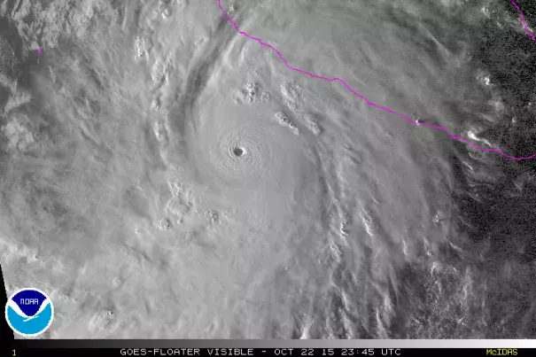
Satellites are critical for tracking and studying hurricanes from their formation to dissipation. These orbiting devices provide continuous, real-time data on atmospheric conditions, ocean temperatures, and cloud structures.
- Geostationary Satellites: These remain fixed over a particular region, offering constant monitoring of a storm’s development and movement. For example, NOAA’s GOES satellites provide high-resolution images and data.
- Polar-Orbiting Satellites: These pass over different parts of the Earth, capturing detailed snapshots of storms and their surroundings. Instruments like the Advanced Microwave Sounding Unit (AMSU) provide insights into rainfall, wind speeds, and temperature profiles.
- Infrared and Visible Imaging: Satellites capture cloud-top temperatures and storm intensity, helping scientists measure a hurricane’s strength and organization.
Aircraft Reconnaissance
Specialized aircraft, known as “hurricane hunters,” fly directly into hurricanes to gather data that satellites cannot.
- Instruments on Board: These aircraft carry devices like dropsondes, which are released into the storm to measure temperature, pressure, humidity, and wind speed at various altitudes.
- Flight Patterns: Pilots fly into the hurricane’s eye and surrounding regions to map its structure and intensity.
- Contribution: The data collected by hurricane hunters improve the accuracy of forecasting models and help pinpoint the storm’s center and potential changes in strength.
Oceanographic Observations
Hurricanes are deeply connected to oceanic conditions, and studying the sea surface is vital.
- Buoys: Moored and drifting buoys equipped with sensors measure sea surface temperatures, wave heights, and wind speeds, providing real-time information.
- Argo Floats: These autonomous devices collect data on ocean temperature and salinity at different depths, helping to understand the ocean’s role in hurricane intensity.
- Unmanned Surface Vehicles: Instruments like wave gliders and saildrones collect data in dangerous conditions where manned vessels cannot operate.
Weather Radars
Land-based Doppler radar systems are essential for monitoring hurricanes as they approach coastlines.
- Function: Doppler radars detect precipitation, wind patterns, and the movement of storm bands.
- Benefits: These systems provide high-resolution data on rainfall distribution and storm structure, which is crucial for short-term forecasting and issuing warnings.
Numerical Weather Models
Advanced computer simulations are used to predict hurricane behavior based on physics and historical data.
- Dynamic Models: These incorporate real-time data from satellites, aircraft, and other sources to simulate hurricane formation, trajectory, and intensity. Examples include the Global Forecast System (GFS) and the European Centre for Medium-Range Weather Forecasts (ECMWF).
- Ensemble Forecasting: Multiple simulations with slight variations in initial conditions are run to account for uncertainty, providing a range of possible outcomes.
- Climate Models: Long-term models assess how climate change impacts hurricane frequency and intensity.
Field Experiments and Data Collection
Researchers often conduct field campaigns to study specific aspects of hurricanes.
- Mobile Observation Units: Teams deploy weather stations, wind profilers, and other instruments in areas likely to be affected.
- Unmanned Aerial Systems (UAS): Drones equipped with sensors collect data from lower atmospheric layers, particularly in dangerous conditions where manned aircraft cannot fly.
Most powerful hurricanes observed in the past
Typhoon Tip (1979)
Typhoon Tip holds the record as the largest tropical cyclone ever observed, with a diameter of over 1,380 miles (2,220 kilometers). Forming in the western Pacific Ocean, Tip reached peak sustained winds of 190 mph (305 km/h) and a central pressure of 870 millibars, making it one of the most intense storms ever recorded. The typhoon caused significant damage in Guam and Japan, including widespread flooding, landslides, and destroyed infrastructure. Over 86 fatalities were reported, with thousands displaced by the storm’s effects. Tip’s immense size and power demonstrated the extreme energy hurricanes can derive from warm ocean waters. Although its impact was less catastrophic than other major storms due to its trajectory and weakened state at landfall, Tip remains a benchmark for meteorological studies. Its unprecedented scale emphasizes the importance of monitoring and understanding the dynamics of large, intense tropical cyclones.
Hurricane Katrina (2005)
Hurricane Katrina was one of the deadliest and costliest hurricanes in U.S. history. Originating as a tropical depression over the Bahamas, it rapidly intensified into a Category 5 hurricane in the Gulf of Mexico, with sustained winds of 175 mph (280 km/h) and a central pressure of 902 millibars. Katrina made landfall in Louisiana and Mississippi as a strong Category 3 hurricane, bringing a devastating storm surge that overwhelmed levees in New Orleans. The flooding submerged 80% of the city, displaced hundreds of thousands, and caused over 1,800 fatalities. The economic damage exceeded $125 billion, with widespread destruction to homes, infrastructure, and livelihoods. Katrina exposed significant shortcomings in disaster preparedness, emergency response, and infrastructure resilience. The storm also sparked national and global discussions on urban planning, social inequalities, and climate change, marking it as a pivotal event in modern hurricane history.
Hurricane Wilma (2005)
Hurricane Wilma, a record-breaking storm of the hyperactive 2005 Atlantic hurricane season, stands out for its extraordinary intensity. At its peak, Wilma’s central pressure dropped to 882 millibars, making it the most intense hurricane ever recorded in the Atlantic basin. Sustained winds reached 185 mph (295 km/h) as the storm rapidly intensified over the Caribbean Sea. Wilma devastated parts of the Yucatán Peninsula, including Cancun and Cozumel, before making landfall in Florida as a Category 3 hurricane. The storm caused widespread flooding, wind damage, and power outages, with economic losses exceeding $27 billion. Wilma’s rapid intensification and erratic path challenged forecasters and highlighted the unpredictable nature of hurricanes. The storm contributed to the historic 2005 hurricane season, which also included Katrina, Rita, and Stan, and underscored the need for robust disaster response systems in hurricane-prone areas.
Typhoon Haiyan (Yolanda) (2013)
Typhoon Haiyan, known locally as Yolanda, devastated the Philippines in November 2013 and is remembered as one of the strongest tropical cyclones ever to make landfall. With sustained winds of 195 mph (315 km/h) and a central pressure of 895 millibars, Haiyan unleashed catastrophic damage, particularly in the city of Tacloban. The typhoon’s storm surge, reaching heights of up to 20 feet, swept away entire communities, claiming over 6,300 lives and displacing millions. Haiyan destroyed homes, infrastructure, and livelihoods, leaving a humanitarian crisis in its wake. Relief efforts were hindered by widespread devastation and logistical challenges, with many areas cut off for days. The storm underscored the vulnerability of low-lying, densely populated coastal areas to extreme weather. Haiyan also spurred global discussions on climate change and disaster preparedness, emphasizing the need for resilient infrastructure and better early warning systems in vulnerable regions.
Hurricane Patricia (2015)
Hurricane Patricia remains the most powerful tropical cyclone ever recorded in the Western Hemisphere. Originating in the eastern Pacific, Patricia reached peak sustained winds of 215 mph (345 km/h) and a central pressure of 872 millibars, breaking records for intensity. Its rapid intensification was fueled by exceptionally warm ocean waters and low wind shear. Patricia made landfall on Mexico’s Pacific coast as a Category 5 storm but weakened quickly upon encountering mountainous terrain. Despite its unparalleled strength, the hurricane caused surprisingly limited damage and fewer than ten fatalities, largely because it struck a sparsely populated area. However, it left behind extensive flooding, destroyed infrastructure, and damaged crops. The storm highlighted the importance of accurate forecasting and early evacuation efforts, which were credited with saving countless lives. Patricia remains a stark reminder of the destructive potential of hurricanes, particularly in the context of climate change and warming oceans.
Advancements in Hurricane Prediction: Harnessing Technology and Data
In recent decades, the science of predicting hurricane formation has advanced significantly, driven by breakthroughs in observational technologies, data analysis, and computational modeling. Modern satellite systems are the cornerstone of hurricane prediction, providing continuous, real-time data about atmospheric conditions and ocean temperatures across vast regions. Geostationary satellites such as NOAA’s GOES series deliver high-resolution images that track the development of storms, while polar-orbiting satellites like those in the JPSS program offer detailed snapshots of atmospheric variables. These technologies have enhanced the ability to monitor early signs of tropical disturbances, such as warm sea surface temperatures and clusters of thunderstorms, which can evolve into hurricanes. Moreover, specialized satellite sensors, including those measuring microwave radiation, enable scientists to probe through clouds and obtain critical data on wind speed, rainfall, and humidity at various altitudes. These advancements allow for earlier detection of hurricane precursors, offering critical lead time for forecasting efforts.
The Role of Advanced Modeling and Big Data
Numerical weather prediction models have revolutionized hurricane forecasting by simulating complex atmospheric and oceanic processes. These models, such as the Global Forecast System (GFS) and the European Centre for Medium-Range Weather Forecasts (ECMWF), incorporate real-time data from satellites, weather stations, and reconnaissance aircraft. They employ sophisticated algorithms to simulate how weather patterns will evolve, predicting not only the formation of hurricanes but also their paths, intensity, and potential impacts. Ensemble forecasting has further improved reliability by running multiple simulations with slightly varied initial conditions, allowing meteorologists to assess uncertainties and identify likely scenarios. Advances in big data and machine learning have also enhanced predictive capabilities, enabling the processing of vast amounts of information to identify patterns and refine models. These tools have significantly reduced the error margins in hurricane track and intensity forecasts, improving preparedness and response measures in vulnerable regions.
Collaboration and Future Innovations
Global collaboration among meteorological organizations has been pivotal in advancing hurricane prediction. Shared data networks, such as those coordinated by the World Meteorological Organization (WMO), ensure that real-time observations and forecasts are accessible worldwide. Additionally, hurricane reconnaissance missions using aircraft like NOAA’s Hurricane Hunters have provided invaluable in situ data, including direct measurements of wind speed, pressure, and temperature within developing storms. Looking forward, future innovations promise to further enhance predictive accuracy. Emerging technologies, such as unmanned aerial systems (UAS) and oceanographic drones, offer new ways to collect data from inaccessible areas, while quantum computing holds potential for exponentially faster and more complex simulations. Combined with ongoing improvements in climate modeling, these advancements are helping scientists better understand the influences of global warming on hurricane behavior. Together, these efforts aim to minimize the human and economic toll of hurricanes through earlier warnings and more effective mitigation strategies.

