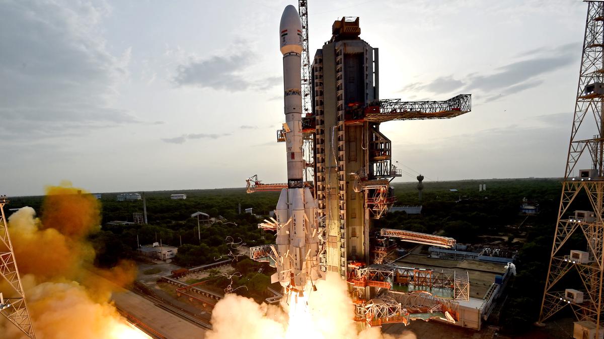
Sriharikota, India – July 30, 2025
A new era in Earth observation was ushered in today as the Indian Space Research Organisation (ISRO) successfully launched the groundbreaking NASA-ISRO Synthetic Aperture Radar (NISAR) satellite aboard its Geosynchronous Satellite Launch Vehicle (GSLV-F16) from the Satish Dhawan Space Centre at 5:40 PM IST. This momentous event marks a significant milestone in global Earth observation and stands as a testament to the robust collaboration between two of the world’s leading space agencies, NASA and ISRO. The 2,393 kg satellite was precisely injected into a 747 km Sun-synchronous polar orbit approximately 19 minutes after liftoff, a first for the GSLV, which has traditionally been used for Geosynchronous Transfer Orbits (GTO).
The NISAR mission, a culmination of over a decade of development and a joint investment exceeding $1.5 billion, is touted as the most expensive Earth observation mission ever launched and a true game-changer in understanding our dynamic planet. Its core strength lies in its unique dual-frequency Synthetic Aperture Radar (SAR) system. NASA has provided the L-band radar, which operates at a wavelength of approximately 24-25 cm, allowing it to penetrate dense vegetation, surface soil, and even ice, providing crucial insights into solid Earth processes and ice mass dynamics. ISRO, on the other hand, has contributed the S-band radar, with a shorter wavelength of about 4 inches (10 cm), which is particularly effective for monitoring soil moisture, crop fields, water bodies, and in polar regions where it is less perturbed by the ionosphere. The combination of these two radar systems, operating in tandem, enables NISAR to capture an unprecedented level of detail, down to changes as small as a few centimeters, day or night, and regardless of cloud cover, making it an all-weather, all-time imaging satellite. This integrated approach allows NISAR to generate comprehensive imagery that would be impossible with two separate satellites. The satellite’s main body, about the length of a pickup truck, houses these advanced radar systems and a deployable 12-meter unfurlable mesh reflector antenna, which resembles a giant beach umbrella and was a significant engineering challenge to integrate.
NISAR’s primary mission objectives are far-reaching and directly address some of the most pressing global challenges. Over its three-year baseline mission, NISAR will scan nearly all of Earth’s land and ice surfaces twice every 12 days, providing continuous, high-resolution data. This rapid revisit rate will revolutionize our ability to monitor critical environmental changes. One of its key applications is in natural hazard surveillance. By detecting minute ground deformation, NISAR will provide crucial data for forecasting and responding to natural disasters such as earthquakes, volcanic eruptions, landslides, and tsunamis. Its ability to measure ground displacement down to millimeter precision will aid in early detection of ground shifts, offering invaluable assistance to disaster management agencies for faster response times and better risk assessments. Another vital area of focus is the cryosphere and sea-level rise. NISAR will track the evolution of ice sheets, glaciers, permafrost, and polar sea ice, quantifying ice mass changes and improving our understanding of how climate change is impacting these regions, including the increasingly urgent concern of glacial lake outburst floods (GLOFs) in the Himalayas. The data will also be instrumental in assessing the impacts of sea-level rise on coastal areas worldwide.
Beyond disaster management and cryosphere monitoring, NISAR will provide critical insights into land ecosystems and environmental change. It will measure biomass and its changes, track the extent of active crops, understand changes in wetland extent, and contribute to improved forest mapping. This data will be invaluable for precision farming, assessing drought and irrigation scheduling, monitoring groundwater recharge, and supporting conservation efforts by detecting deforestation and other land-use changes. The satellite’s ability to penetrate forest canopies with its L-band radar will allow for accurate assessment of biomass, a key factor in carbon cycle studies. Furthermore, NISAR will aid in monitoring infrastructure such as dams, bridges, and roadways, and provide information for ship tracking and oil spill detection, contributing to sustainable resource management. The open-source availability of all NISAR science data, both L-band and S-band, will benefit scientists, governments, and industries globally, consistent with NASA’s long-standing open data policy.
The NISAR mission is a profound symbol of international scientific collaboration. It signifies a remarkable fifty-year journey of Indo-US space cooperation, tracing back to the landmark Satellite Instructional Television Experiment (SITE) in 1975. At that time, India utilized a NASA satellite for educational programming, showcasing the potential of space technology for societal benefit. Today, with NISAR, India is not only launching a NASA payload alongside its own, but also demonstrating its advanced capabilities in developing and launching complex Earth observation satellites. The joint operation of the spacecraft and the sharing of high-priority scientific data underscore the deep trust and mutual benefit in this partnership. ISRO’s contribution includes not only the S-band SAR payload but also the spacecraft bus, the GSLV-F16 launch vehicle, and all associated launch services and mission operations. NASA provided the L-band radar system, a high-speed downlink system, a solid-state recorder, and GPS receivers. This technical exchange and continuous interaction at various levels during project execution have enriched both space agencies, further solidifying India’s position as a global leader in Earth observation and a trusted international space partner. The successful launch of NISAR truly exemplifies the spirit of “Vishwabandhu” – a global friend contributing to the collective good of humanity.


