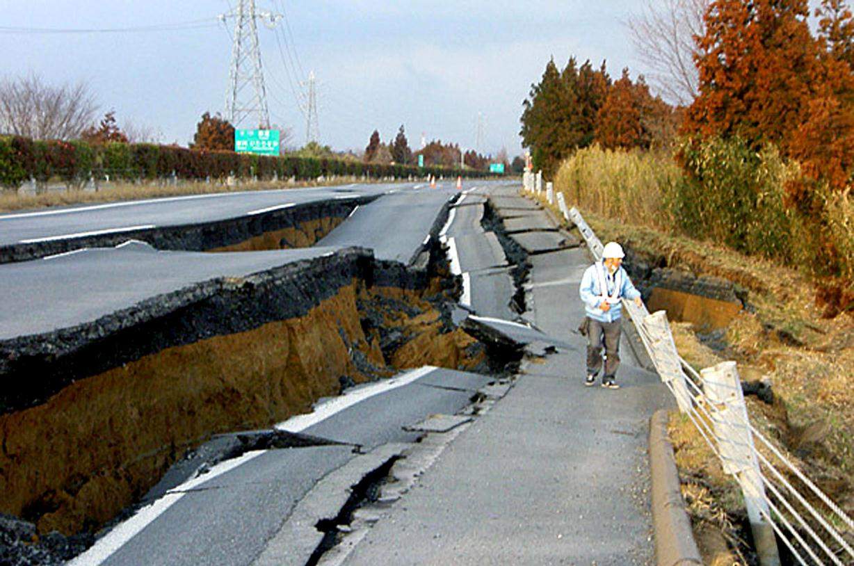
Earthquakes are among the most devastating natural disasters, affecting millions of people globally each year. These sudden and violent ground movements occur when stress accumulated in the Earth’s crust is released along faults, generating seismic waves that travel through the ground. The consequences of earthquakes can be catastrophic, resulting in loss of life, destruction of infrastructure, displacement of communities, and economic hardship. Some of the deadliest earthquakes in history, such as the 2004 Indian Ocean earthquake and the 2011 Tōhoku earthquake in Japan, have demonstrated the need for effective monitoring and prediction systems to minimize their impact.
Despite significant advances in geophysics, earthquake prediction remains one of the most complex challenges in science. Unlike other natural disasters, such as hurricanes or floods, which can be anticipated with reasonable accuracy, earthquakes strike suddenly and without clear warning. The unpredictability of seismic activity is primarily due to the complex and dynamic nature of tectonic plate movements and the difficulty of identifying precursors that reliably indicate an impending earthquake. As a result, scientists and researchers have focused on developing sophisticated technologies to monitor seismic activity, analyze geological patterns, and provide early warnings to mitigate damage.
Over the past few decades, advancements in technology have significantly improved our ability to detect and analyze earthquakes. Modern tools such as seismometers, GPS tracking systems, satellite remote sensing, and artificial intelligence have enhanced our understanding of seismic activities and allowed for more effective disaster preparedness. While an exact prediction system remains elusive, these technological innovations have enabled better early warning systems, allowing authorities and individuals to take precautionary measures before the most destructive shaking begins. In this article, we shall read about the causes and effects of earthquakes, the challenges in predicting them, and the latest technological developments that aid in earthquake monitoring and risk mitigation.
Understanding Earthquakes
Causes of Earthquakes
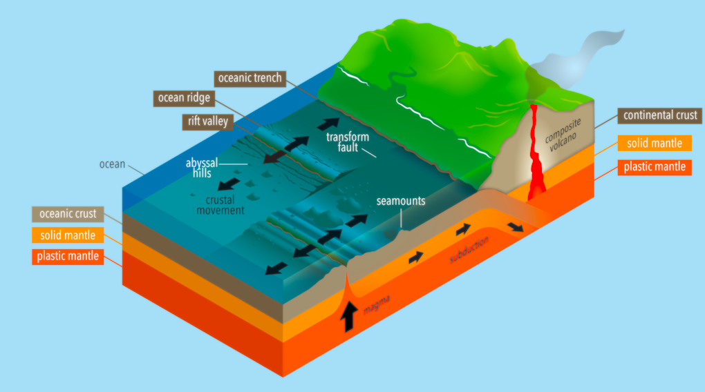
Earthquakes occur due to various natural and human-induced factors. The primary cause of earthquakes is the movement of tectonic plates, which make up the Earth’s lithosphere. These plates are constantly in motion due to convection currents in the mantle, and their interactions along plate boundaries result in seismic activity. There are three main types of plate boundaries where earthquakes frequently occur:
- Divergent Boundaries: Plates move apart, creating new crust and causing minor seismic activity.
- Convergent Boundaries: Plates collide, often leading to powerful earthquakes and the formation of mountain ranges or subduction zones.
- Transform Boundaries: Plates slide past each other horizontally, generating significant seismic stress and resulting in frequent earthquakes, such as along the San Andreas Fault in California.
Other natural causes of earthquakes include volcanic activity and geological stress accumulation. Volcanic earthquakes occur when magma movement creates pressure, leading to fracturing of the surrounding rock. These are typically localized but can be highly destructive, especially in volcanic regions.
Human activities can also induce earthquakes. This phenomenon, known as induced seismicity, occurs due to activities such as:
- Mining Operations: Underground explosions or excavations can destabilize geological structures.
- Reservoir-Induced Seismicity: Large artificial reservoirs create immense pressure on fault lines, triggering seismic activity.
- Hydraulic Fracturing (Fracking): The injection of high-pressure fluids into underground rock formations can activate faults and cause minor to moderate earthquakes.
Seismic Waves and Their Effects
When an earthquake occurs, energy is released in the form of seismic waves that propagate through the Earth’s interior and surface. These waves are classified into three main types:
- Primary (P) Waves: These are the fastest seismic waves and can travel through solids, liquids, and gases. They cause particles to move in a compressional manner, similar to sound waves.
- Secondary (S) Waves: These waves travel slower than P-waves and can only move through solid materials. They create perpendicular motion relative to the wave’s direction, causing strong shaking.
- Surface Waves: These waves travel along the Earth’s surface and cause the most destruction due to their high amplitude and long duration. Two main types of surface waves include Love waves (horizontal motion) and Rayleigh waves (rolling motion).
Magnitude, Depth, and Impact of Earthquakes
The severity of an earthquake is determined by its magnitude and depth. Magnitude refers to the total energy released during an earthquake and is measured using the Richter scale or the Moment Magnitude Scale (Mw). The depth of an earthquake’s focus also plays a crucial role in determining its impact:
- Shallow Earthquakes (0-70 km depth): Cause the most destruction due to their proximity to the surface.
- Intermediate Earthquakes (70-300 km depth): Generally less damaging but can be felt over wider areas.
- Deep Earthquakes (300+ km depth): Less likely to cause significant damage at the surface but can influence seismic activity in distant regions.
The impact of an earthquake also depends on local geological conditions, building structures, and population density. Regions with poor infrastructure and high population densities are more vulnerable to catastrophic losses. Secondary effects such as landslides, tsunamis, and soil liquefaction can further exacerbate the damage caused by an earthquake.
Understanding the mechanisms behind earthquakes allows scientists to develop better monitoring and mitigation strategies, ultimately reducing their impact on human society.
Challenges in Predicting Earthquakes
Earthquake prediction remains one of the greatest challenges in geophysics due to the complexity of tectonic processes and the lack of definitive precursors. Several key challenges hinder accurate earthquake forecasting:
- Complexity of Fault Systems: The Earth’s crust consists of intricate fault networks, and the behavior of these faults is highly unpredictable. Some faults remain inactive for centuries before suddenly producing a major earthquake, making long-term forecasting difficult.
- Lack of Reliable Precursor Signals: Unlike weather patterns, which exhibit gradual changes before a storm, earthquakes often occur suddenly without clear warning signs. While researchers have identified potential precursors such as foreshocks, ground deformation, and gas emissions, none of these have proven to be consistently reliable indicators.
- Variability in Seismic Activity: Earthquakes do not follow a fixed pattern. Some regions experience frequent minor tremors without leading to a major quake, while others may remain seismically quiet before producing a devastating event. This variability complicates predictive models.
- Limited Understanding of Subsurface Processes: Many geological processes that contribute to earthquakes occur deep within the Earth’s crust and mantle, beyond the reach of direct observation. Despite advances in geophysical imaging, our knowledge of subsurface stress accumulation and energy release remains incomplete.
- Short-Term vs. Long-Term Predictions: While scientists can estimate long-term seismic hazard probabilities based on historical data and fault activity, short-term prediction—identifying exactly when and where an earthquake will occur—remains elusive. Current early warning systems provide only seconds to minutes of notice before shaking begins.
- Influence of External Factors: Seismic activity can be influenced by external factors such as seasonal changes, atmospheric pressure variations, and even human activities like deep fluid injection. Understanding how these factors interact with tectonic stress is a significant research challenge.
Despite these challenges, technological advancements continue to improve earthquake monitoring and risk assessment, providing valuable tools for disaster preparedness and mitigation.
Technologies Used to Predict and Monitor Earthquakes
Seismic Monitoring Technologies
Seismic monitoring is the backbone of earthquake detection. It involves tracking seismic waves generated by tectonic activity.
a) Seismometers and Accelerometers
- Seismometers detect even the smallest ground vibrations caused by tectonic movements.
- Accelerometers measure ground acceleration, providing data on the intensity of shaking.
- Modern digital seismometers convert ground movements into electrical signals for real-time analysis.
b) Seismic Networks
- National and international networks of seismometers are deployed to track seismic activity.
- Examples include the US Geological Survey (USGS) Seismic Network, Japan Meteorological Agency (JMA) Seismic Network, and the Global Seismographic Network (GSN).
- Data from multiple stations help pinpoint the location, depth, and magnitude of an earthquake.
c) Strong Motion Sensors
- Installed in buildings, dams, and bridges to measure the intensity of shaking.
- Used for engineering assessments and improving earthquake-resistant designs.
Global Positioning System (GPS) and Geodetic Methods
a) GPS Stations
- Continuously monitor ground displacement caused by slow-moving tectonic plates.
- Help identify strain accumulation in earthquake-prone regions.
- Example: NASA’s GPS network tracks fault line movements worldwide.
b) Interferometric Synthetic Aperture Radar (InSAR)
- Uses radar satellites to capture detailed images of the Earth’s surface before and after seismic events.
- Helps detect minor deformations that indicate potential seismic activity.
- Example: The European Space Agency’s Sentinel-1 satellites use InSAR technology.
Machine Learning and Artificial Intelligence (AI)
a) AI-Based Earthquake Prediction Models
- AI algorithms analyze historical earthquake data and real-time seismic patterns.
- Machine learning models process vast datasets to detect early warning signs.
- Deep learning techniques improve accuracy in detecting precursor signals.
b) AI-Powered Seismic Data Analysis
- AI helps in real-time interpretation of seismic data, reducing human error.
- Example: Google’s AI-powered earthquake alerts on Android devices detect tremors using smartphone sensors.
Early Warning Systems
a) Seismic Early Warning Networks
- Use real-time seismic data to issue alerts before major tremors arrive.
- Examples of Early Warning Systems:
- ShakeAlert (USA)
- J-ALERT (Japan)
- SASMEX (Mexico)
b) P-Wave Detection Technology
- P-waves (primary waves) are the fastest seismic waves but cause little damage.
- Early warning systems detect P-waves before destructive S-waves (secondary waves) arrive, giving people valuable seconds to minutes to prepare.
c) Public Alert Systems
- Alerts are sent via mobile phones, TV, radio, sirens, and smart home devices.
- Example: Japan’s Earthquake Early Warning (EEW) system sends automatic alerts to trains, elevators, and gas lines to prevent accidents.
Electromagnetic and Geochemical Monitoring
a) Electromagnetic Sensors
- Measure changes in the Earth’s electromagnetic field, which might indicate seismic activity.
- Some researchers suggest that stressed rocks emit electromagnetic signals before an earthquake.
b) Radon Gas Emission Monitoring
- Scientists monitor radon gas levels in groundwater.
- Studies suggest that radon gas levels increase before an earthquake due to cracks in underground rock formations.
- However, this method is still under research and not a reliable standalone predictor.
Ocean-Based Monitoring
a) Tsunami Warning Buoys
- Deployed in oceans to detect undersea earthquakes and potential tsunamis.
- Example: The Deep-ocean Assessment and Reporting of Tsunamis (DART) system provides real-time alerts.
b) Deep-Sea Seismometers
- Installed on the ocean floor to detect undersea seismic activity.
- Provide valuable data on subduction zones, where major earthquakes and tsunamis originate.
- Example: Japan’s DONET and S-net systems monitor deep-sea seismic movements.
Smartphone and IoT-Based Detection
a) Crowdsourced Seismic Data from Smartphones
- Smartphone accelerometers can detect ground shaking.
- Apps like MyShake (developed by UC Berkeley) collect seismic data from users worldwide.
- Data from thousands of users help scientists study earthquakes in real time.
b) Internet of Things (IoT) Sensors
- IoT devices with seismic sensors are installed in smart homes and industrial buildings.
- Help detect early tremors and automatically shut down hazardous systems (e.g., gas pipelines).
- Example: Early Warning Labs integrates IoT-based earthquake detection in smart cities.
The Future of Earthquake Prediction
Despite technological progress, achieving precise earthquake predictions remains a distant goal. However, ongoing research and innovations may bring us closer to:
- Real-Time Hazard Assessments: AI-driven models providing continuous risk analysis.
- Enhanced Early Warning Systems: Faster detection and more accurate predictions.
- Integrated Monitoring Networks: Combining seismometers, satellites, and AI for holistic seismic analysis.
- Community-Based Alert Systems: Improved dissemination of warnings to at-risk populations.
In conclusion, earthquakes remain one of the most unpredictable natural disasters, but advancements in technology have significantly improved our ability to monitor and mitigate their effects. While precise predictions are not yet possible, tools such as seismometers, GPS, AI, and remote sensing have enhanced early warning capabilities and risk assessments. Continued research and technological innovation offer hope for a future where the devastating impact of earthquakes can be minimized, potentially saving millions of lives worldwide.


