September 27, 2025
The People’s Republic of China executed a breathtaking display of aerospace prowess and logistical coordination, successfully launching three distinct rockets from separate spaceports within a single 24-hour period. This unprecedented flurry of activity, unprecedented in its scale and ambition for a single nation in one day, was aimed at simultaneously bolstering three critical areas of its national infrastructure: global broadband connectivity, the Internet of Things (IoT), and next-generation meteorological forecasting. The launches, occurring from the Gobi Desert to the tropical island of Hainan, signify a monumental leap in China’s strategy to achieve technological self-reliance and establish a dominant presence in both the economic and scientific spheres of space.
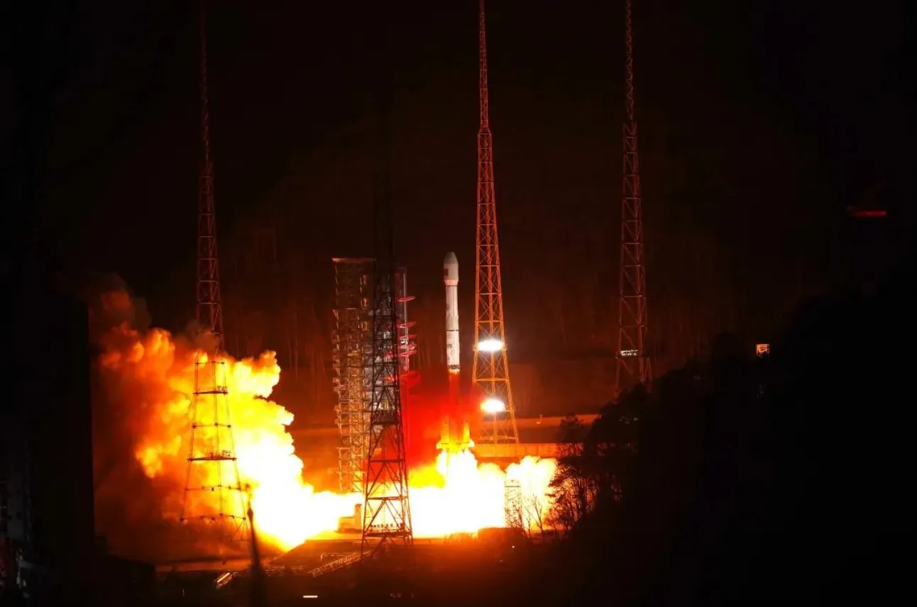
The day’s space-bound marathon commenced at 06:15 AM local time (22:15 UTC, September 26) from the Jiuquan Satellite Launch Center in the Inner Mongolia autonomous region. A Kuaizhou-1A (KZ-1A) solid-fuel rocket roared to life, carrying a single, high-capacity communications satellite designated Zhongxing-31. This satellite is the cornerstone of a new, sophisticated Geostationary Orbit (GEO) broadband constellation intended to provide high-speed internet access to remote and underserved regions across China and the broader Asia-Pacific. The primary mission of Zhongxing-31 is to bridge the digital divide, ensuring that even the most isolated communities have access to the economic and educational opportunities afforded by reliable connectivity. This has significant implications for national development and is seen as a critical step in China’s “Digital Silk Road” initiative, enhancing digital infrastructure alongside physical trade routes. The successful insertion of Zhongxing-31 into its planned geostationary transfer orbit was confirmed by the China Aerospace Science and Technology Corporation (CASC) within an hour of launch.
Merely hours later, the focus shifted to the Xichang Satellite Launch Center in Sichuan province. At 11:42 AM local time (03:42 UTC), a more powerful Long March 2D rocket ascended into the sky, its payload being a cluster of seven satellites. This mission was dedicated to the expansion of the Xingyun satellite constellation, a pioneering project operated by the private(ish) firm Xingyun Satellite Co., a subsidiary of the state-owned China Aerospace Science and Industry Corporation (CASIC). The launch of these seven satellites marks a critical phase in deploying the world’s first low-Earth orbit (LEO) narrowband constellation dedicated exclusively to the Internet of Things (IoT). These compact satellites are designed to collect and relay small packets of data from a vast network of sensors and devices deployed on Earth, from tracking shipping containers across the oceans and monitoring soil moisture on smart farms to providing real-time data from infrastructure like pipelines and power grids in areas without terrestrial coverage. A project manager from Xingyun Satellite Co., speaking on condition of anonymity as they were not authorized to speak publicly, stated, “This second-phase expansion is a game-changer. With this enhanced orbital capacity, we can offer near-global coverage with a latency of mere minutes, enabling a level of asset tracking and environmental monitoring that was previously impossible for many industries.”
The grand finale of this historic triple-header took place from the coastal Wenchang Space Launch Site on Hainan Island. Under the cover of darkness, at 08:05 PM local time (12:05 UTC), the most powerful rocket in China’s arsenal, the Long March 5B, ignited its massive engines, lighting up the night sky. Its payload was the Fengyun-5A, a behemoth of a weather satellite representing the pinnacle of Chinese meteorological technology. Unlike the smaller satellites launched earlier, Fengyun-5A is destined for a geostationary orbit approximately 36,000 kilometers above the Earth, where it will maintain a fixed position over the Asia-Pacific region. Fengyun-5A is equipped with a next-generation hyperspectral imager and an advanced atmospheric sounder, instruments capable of providing continuous, high-resolution imagery and atmospheric data with unprecedented frequency. This allows for the monitoring of rapidly developing weather phenomena, including typhoons, severe thunderstorms, and torrential rainfall, with updates available as frequently as every 30 seconds. This capability is vital for improving the accuracy and lead time of severe weather warnings, which have immense implications for disaster preparedness, aviation, agriculture, and public safety for billions of people. Dr. Wei Ming, a lead scientist at the National Satellite Meteorological Center (NSMC), emphasized the satellite’s significance in an official statement: *”Fengyun-5A is not just an incremental improvement; it’s a generational leap. The data fidelity from its new instruments will fundamentally enhance our numerical weather prediction models. We anticipate a significant improvement in our ability to track the intensity and path of typhoons, potentially saving countless lives and reducing economic losses.”*
The coordination required to execute three launches from three different locations in a single day cannot be overstated. It involved the seamless work of thousands of personnel, multiple launch vehicle families, and separate tracking and command networks. This achievement serves as a powerful demonstration of the maturity and redundancy China has built into its space launch infrastructure. This triple launch underscores China’s strategic shift towards mass production and rapid deployment of space assets, a model reminiscent of other commercial space entities but applied here on a national, strategic scale. The ability to rapidly replenish and expand satellite constellations is a critical military and economic advantage, ensuring resilience and continuous service.
The international community has observed these developments with a mixture of admiration and apprehension. The technological benefits of improved weather forecasting and enhanced global connectivity are undeniable and offer potential collaborations. However, the dual-use nature of satellite technology remains a point of geopolitical concern. Advanced imaging and communication satellites can be used for civilian purposes but also have significant military applications, from battlefield communications to surveillance. The rapid expansion of China’s space-based capabilities is closely watched by other spacefaring nations, who are assessing the implications for strategic competition in orbit and on Earth. Furthermore, the launches add to the growing problem of space debris, particularly the deployment of numerous satellites in low-Earth orbit, raising questions about long-term sustainability and traffic management in an increasingly crowded space environment.


