
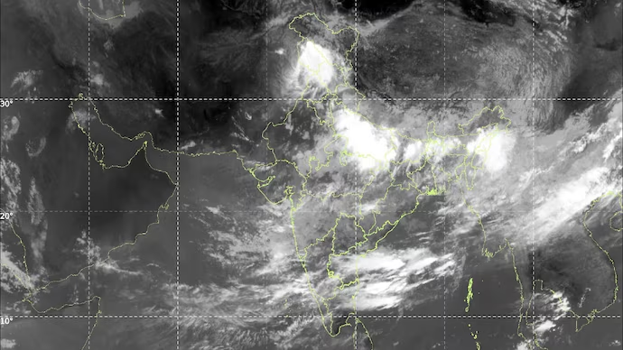
A striking satellite image from the Indian Space Research Organisation (ISRO) has captured a dramatic visual divide over India, where thick clouds blanket large parts of the eastern and southern regions while western and northwestern India remain relatively clear, creating the appearance of the country being split into two distinct weather zones .
The image was captured by India’s INSAT-3DS weather satellite on September 24-25, 2026, using its thermal infrared channel at a wavelength of 10.83 micrometres, a technology that allows meteorologists to record cloud position and density clearly during both day and night . The most prominent feature is a broad, bright cloud mass extending from the Bay of Bengal across eastern and northeastern India, with additional cloud bands visible over the southern peninsula and adjoining oceanic regions . In contrast, much of western and northwestern India appears relatively cloud-free, creating a sharp visual divide between the two halves of the subcontinent .
The satellite imagery covers several states under dense cloud cover, including Odisha, Tamil Nadu, Telangana, Andhra Pradesh, West Bengal, Assam, and Chhattisgarh, while Gujarat, Rajasthan, Punjab, and Haryana show largely clear skies . The brightest regions in the infrared image represent colder, higher cloud tops, which are typically associated with deep convection and heavy rainfall, particularly when linked to active weather systems .
Meteorological Causes Behind the Divide
This unusual cloud pattern coincides with the withdrawal phase of the southwest monsoon, which began retreating from parts of West Rajasthan around September 19, 2026 . As the monsoon withdraws from the northwest, atmospheric moisture levels drop, leaving the region dry and cloud-free . The India Meteorological Department confirmed that the monsoon withdrawal line now passes through Gurdaspur, Chandigarh, Muzaffarnagar, Aligarh, Dholpur, Udaipur, Deesa and Naliya, indicating the retreat’s northwestward progression .
Meanwhile, a deep depression over north coastal Andhra Pradesh and adjoining south Odisha has been driving the extensive cloud cover over the eastern and southern regions . This weather system originated over the west-central and adjoining northwest Bay of Bengal and intensified into a deep depression on September 22, moving west-northwestwards at approximately 7 kmph before crossing the coast between Visakhapatnam and Gopalpur . The system has been responsible for widespread rainfall across Odisha, Chhattisgarh and neighbouring regions, with the IMD warning of heavy to very heavy rain and isolated extremely heavy rainfall in parts of eastern and central India .
Moisture-laden winds from the Bay of Bengal are being transported into the Indian landmass, sustaining cloud formation and rainfall over the eastern and southern peninsula . This explains why the deep depression continues to drive precipitation even as the monsoon retreats from the northwest .
Implications and Weather Outlook
The apparent “divide” in the satellite image is not a physical boundary but rather a reflection of the sharp contrast between areas under active convection and regions where the atmosphere has become drier and clearer . As the deep depression weakens while moving northwestwards, its circulation is expected to continue driving rainfall over parts of central India, but the cloud pattern is forecast to evolve rapidly over the next 24-48 hours .
The deep depression has already caused significant disruption. In Odisha, more than 8,000 people have been evacuated from low-lying and landslide-prone areas, with schools closed in several districts and four trains cancelled due to landslides between Maligura and Chatriput stations . The IMD has issued red alerts for Koraput, Nabarangpur and Kalahandi districts, with heavy rainfall expected to continue through September 26-27 .
For Delhi and the surrounding National Capital Region, the monsoon withdrawal on September 23 marked the earliest retreat since 2002, bringing drier weather and no rainfall warnings for the following week . This early withdrawal, combined with the 15% all-India rainfall deficit recorded this season, has raised concerns about agricultural output, with some projections suggesting a potential 10 million tonne reduction in rice production .
The INSAT-3DS satellite, part of India’s meteorological satellite programme, provides observations of clouds, atmospheric temperature, humidity and other weather parameters used by the IMD for weather forecasting, monitoring severe weather, and tracking atmospheric systems . Its thermal infrared instrument detects radiation emitted by Earth and the atmosphere, enabling continuous observation of cloud patterns even at night .
This striking image serves as a powerful visual reminder of how dramatically weather conditions can vary across India at a single point in time, as different atmospheric systems shape the country’s diverse meteorological landscape .