
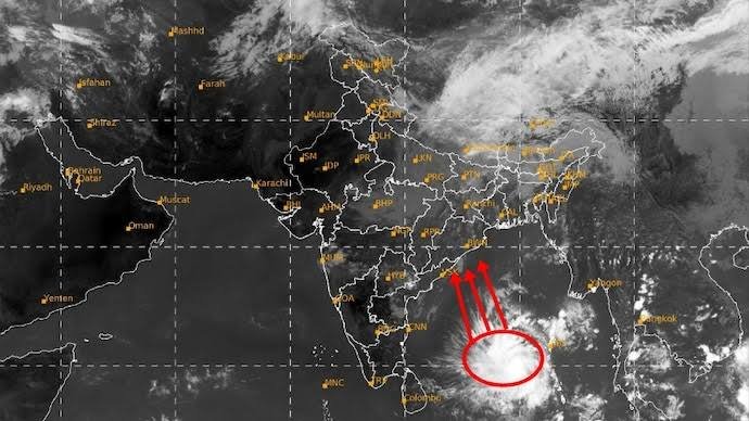
The Indian Space Research Organisation (ISRO) has once again demonstrated the critical importance of its indigenous Earth observation infrastructure by capturing a nascent, highly active weather system developing over the Andaman Sea. High-resolution imagery streamed from India’s state-of-the-art meteorological satellite, INSAT-3DS, has successfully recorded an expansive and organized cluster of convective clouds and thunderstorms swirling across the tropical expanse of the Southeast Bay of Bengal and the Andaman Sea. This newly detected meteorological disturbance marks a significant shift in regional weather patterns, signaling the potential onset of a turbulent phase across the maritime corridors of the eastern Indian Ocean. As regional atmospheric conditions transition, the ability of ISRO’s spaceborne sensors to detect early-stage atmospheric anomalies provides meteorologists with an invaluable head start in monitoring potentially hazardous weather events before they coalesce into severe storms.
The genesis of this brewing weather system can be traced back to an upper-air cyclonic circulation that hovered over the central parts of the Andaman Sea and the Andaman and Nicobar Islands. Under the persistent dynamic influence of this circulation, a formal low-pressure area consolidated over the region, drawing energy from the warm, moisture-laden surface waters characteristic of the late-autumn tropical zone. Meteorological analysis driven by satellite data indicates that the system possesses a well-defined vortex structure, characterized by deep, persistent convection and formative rain bands wrapping around a consolidating low-level center. The thermal energy trapped within these tropical waters acts as a primary engine, feeding the towering convective clouds captured vividly in the infrared and water-vapor channels of the INSAT-3DS payload, which monitors atmospheric moisture dynamics around the clock.
A defining feature of this newly identified weather disturbance is its capability to generate gusty winds and squally weather conditions across vast stretches of the maritime domain. Real-time telemetry from ISRO’s satellite network highlights significant pressure gradients beginning to form around the core of the disturbance, accelerating wind speeds across the open sea and creating choppy, hazardous conditions for local shipping, navigation, and marine operations. The presence of intense thunderstorm activity embedded within the outer bands of the system means that localized squalls, accompanied by sudden drops in visibility and sharp gusts, are sweeping across portions of the South and North Andaman Sea. These dynamic wind patterns are being closely scrutinized by meteorological experts to evaluate the potential for further structural organization and acceleration as the system matures over open waters.
The seamless collaboration between ISRO’s Meteorological and Oceanographic Satellite Data Archival Centre (MOSDAC) and the India Meteorological Department (IMD) ensures that these high-cadence satellite observations are translated immediately into actionable meteorological forecasts. Forecasters rely heavily on the continuous stream of multispectral data provided by INSAT-3DS to track cloud top temperatures, moisture fluxes, and wind vectors with unprecedented precision. Because maritime systems in the Bay of Bengal are notorious for rapid shifts in intensity and trajectory, the advanced imaging capabilities of prescription satellites offer a distinct operational advantage, allowing researchers to observe minute structural changes in the cloud canopy that traditional surface-level buoys and coastal radar networks might otherwise fail to capture in real time.
Looking ahead at the projected trajectory, meteorological projections indicate that the system is expected to track in a northwestward direction over the coming days. Current tracking models evaluated by the IMD suggest that the disturbance will likely consolidate further into a well-marked low-pressure area before potentially intensifying into a full-fledged depression over the central and eastern regions of the Bay of Bengal. The next forty-eight hours remain a critical window of observation, during which satellite updates will determine whether environmental factors such as ambient wind shear and oceanic heat content will support further intensification or cause the system to stabilize as it moves further away from the archipelago.
For the island territories of the Andaman and Nicobar chain, the immediate local implications involve intermittent spells of widespread rainfall, heavy downpours, and rough sea conditions. Local authorities and disaster response units have been placed on heightened awareness, utilizing the early insights provided by space technology to issue timely advisories to fishermen, tour operators, and marine vessels operating in the region. The ability to anticipate heavy precipitation and rough seas well in advance minimizes the risk to human life and property, underscoring how vital space infrastructure has become to day-to-day disaster preparedness in vulnerable coastal zones and remote island communities.
Ultimately, the tracking of this developing Andaman Sea rain system highlights the indispensable role that India’s indigenous space program plays in regional climate monitoring and disaster management. Through the continuous vigilance maintained by spacecraft like INSAT-3DS, ISRO continues to provide the foundational data necessary to safeguard millions of lives residing along the densely populated eastern coastline of the Indian subcontinent and its surrounding island territories. As this particular weather system continues to evolve and navigate across the warm waters of the Bay of Bengal, the seamless integration of spaceborne remote sensing and ground-based meteorological forecasting will remain India’s primary shield against the unpredictable forces of tropical meteorology, ensuring comprehensive preparedness at every single level of governance.