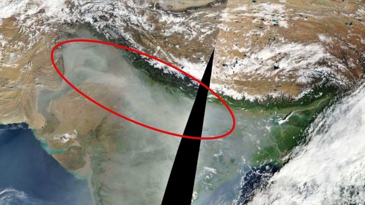
High-resolution satellite imagery captured by Earth-observing instruments, including NASA’s Moderate Resolution Imaging Spectroradiometer (MODIS) mounted on the Terra and Aqua satellites, presents a striking visual record of a massive pollution crisis across South Asia. Two days following the widespread celebrations of Diwali, orbital photos show an expansive, dense cloud of grey haze engulfing the Indo-Gangetic Plains, stretching uninterrupted across thousands of kilometers. This atmospheric phenomenon demonstrates how local post-festival emissions blend with seasonal agricultural practices and geographical traps to create an environmental emergency visible clearly from space.
The satellite visual renders a dramatic geographic contrast between the snow-capped peaks of the Himalayan mountain range to the north and the heavily blanketed lowlands below. The white snow cover of the high peaks remains sharp, while the vast plains of Punjab, Haryana, Delhi, Uttar Pradesh, and parts of Rajasthan and Bihar appear almost entirely submerged beneath an opaque sheet of grey particulate matter. The natural wall formed by the Himalayas acts as a physical barrier, trapping the cold, heavy air mass within the plains and preventing the vertical or lateral dispersion of the toxic atmospheric canopy.
A major factor highlighted in the imagery is the regional scale of the smog layer, which ignores international boundaries. The continuous cloud of smoke extends from eastern Pakistan across northern India into the eastern states, showing that air quality deterioration in this belt is a broader regional atmospheric crisis rather than an isolated urban issue. Spacecraft observations reveal that millions of residents across multiple provinces live under the exact same concentrated toxic dome, where ground-level visibility drops sharply and ambient sun exposure is noticeably dimmed.
Overlaid on the satellite true-color imagery are numerous distinct red thermal markers detected by the Fire Information for Resource Management System (FIRMS). These thermal anomalies highlight hundreds of active farm fire hotspots concentrated throughout the agricultural heartland of Punjab and Haryana. The practice of paddy stubble burning, used by farmers to rapidly clear fields for the winter wheat crop sowing, releases immense volumes of fine particulate matter, carbon monoxide, and volatile organic compounds into the lower troposphere.
The timing of Diwali introduces a critical combustion load to an already fragile air basin. The intense burst of firecracker emissions during the night of the festival introduces heavy metals, sulfates, nitrates, and toxic chemical residues into the surface air layer. Ground monitoring stations across the National Capital Region and neighboring states recorded sharp spikes in PM2.5 and PM10 concentrations, pushing the regional Air Quality Index (AQI) into the ‘Very Poor’ and ‘Severe’ categories. The satellite images capture this immediate accumulation, showing how chemical smoke from pyrotechnics combines with agricultural emissions to form a dense chemical soup.
Meteorological conditions during early November play an active role in solidifying the thick layer shown in the satellite frames. As early winter sets in, dropping ambient temperatures combined with low surface wind speeds reduce thermal convection. This meteorological state triggers a severe temperature inversion layer, where a warm air layer sits above a cooler surface layer, acting like a tight lid on the basin. Under these stagnant conditions, heavy urban pollutants—including vehicular exhaust, industrial emissions, and construction dust—are unable to rise or blow away, causing them to accumulate densely ground-level.
The satellite imagery provides essential scientific data for atmospheric modeling and public health advisories. Medical experts reviewing ground-level correlates to the space observations warn of severe health consequences for populations living beneath the haze layer. Prolonged exposure to high concentrations of fine particulate matter (PM2.5) poses severe risks to vulnerable groups, including children, the elderly, and individuals with preexisting cardiovascular and respiratory conditions. The orbital view serves as a powerful reminder of how anthropogenic actions and geography interact, transforming seasonal celebrations and routine farming into a broad environmental challenge visible across the continent.